Vectorizing an airfield: data collection to valid results
Although many of us have not been to an airport for a long time, we are familiar with the layout: typically large spaces, some tarmacked areas, and a variety of buildings for hosting passengers, planes, and cargo. Where was the first airport? Technically, the word “airport” was coined at Bader Field, also known as Atlantic City Municipal Airport, in New Jersey, USA. The site opened in 1910 and stopped serving as a commercial service in the 1990s and closed permanently in 2006. The big space left behind is city-owned and has a variety of uses.
The Atlantic City Office of Emergency Management is led by Fire Chief Scott Evans and includes a specialized drone program with 15 FAA pilots working with the fire and police departments as well as public works and city hall personnel. Bader Field currently hosts the Atlantic City Fire Department’s Station 5 amongst other facilities. The space is also used to train drivers in the police and firefighter departments, as well as host sanctioned racing and events like concerts and festivals. Over 2020, the site became a drive-through Covid-19 testing site and a Food Drive location to support the local community.
In September of 2020, Firefighter Jamieson Allen of the Drone Program was tasked with surveying the entire site of Bader Field. The asset needed to be fully digitized so all stakeholders had up-to-date information about the site. Due to the range of uses of Bader Field’s space, several different departments under the city authorities needed the data. It was immediately planned for use in:
- Maintaining infrastructure
- Planning training for city entities
- Planning events
- Tracking construction on site
A high level of detail was needed to provide an in-depth understanding of the layout of the terrain and nearby waterbody. So apart from gathering images and processing them with photogrammetry software, the team needed to vectorize their outputs, for which they used PIX4Dsurvey.
Project details
| User | Atlantic City Fire Department |
| Location | Bader Field, New Jersey |
| Software | PIX4Dcapture PIX4Dcloud PIX4Dsurvey Esri ArcMap and ArcGISOnline |
| Hardware | Parrot Anafi |
| Images captured | 2307 |
| Processing time | 10 hours on PIX4Dcloud 2 hours on PIX4Dsurvey |
| Flight time | 4 hours |
| Area surveyed | 170 acres (68 hectares) |
| GSD | 1.82 cm |
| Total points in point cloud | 258,703,877 |
Data collection with drones
This project first involved the PIX4Dcapture app. Although it was an airfield, the airspace there is now classified as Class G, and therefore flying was not hazardous to any other activities in the area. The site was 170 acres (68 hectares), which is a large space to survey. Using the Parrot Anafi, the data collection was broken down into 11 flights. The weather was consistent, with continuous clouds that helped eliminate shadows. However, the wind was blowing at 18 mph with gusts over 20, which was a slight challenge in keeping the drone on course. After 4 hours of flying, all of the data had been collected.
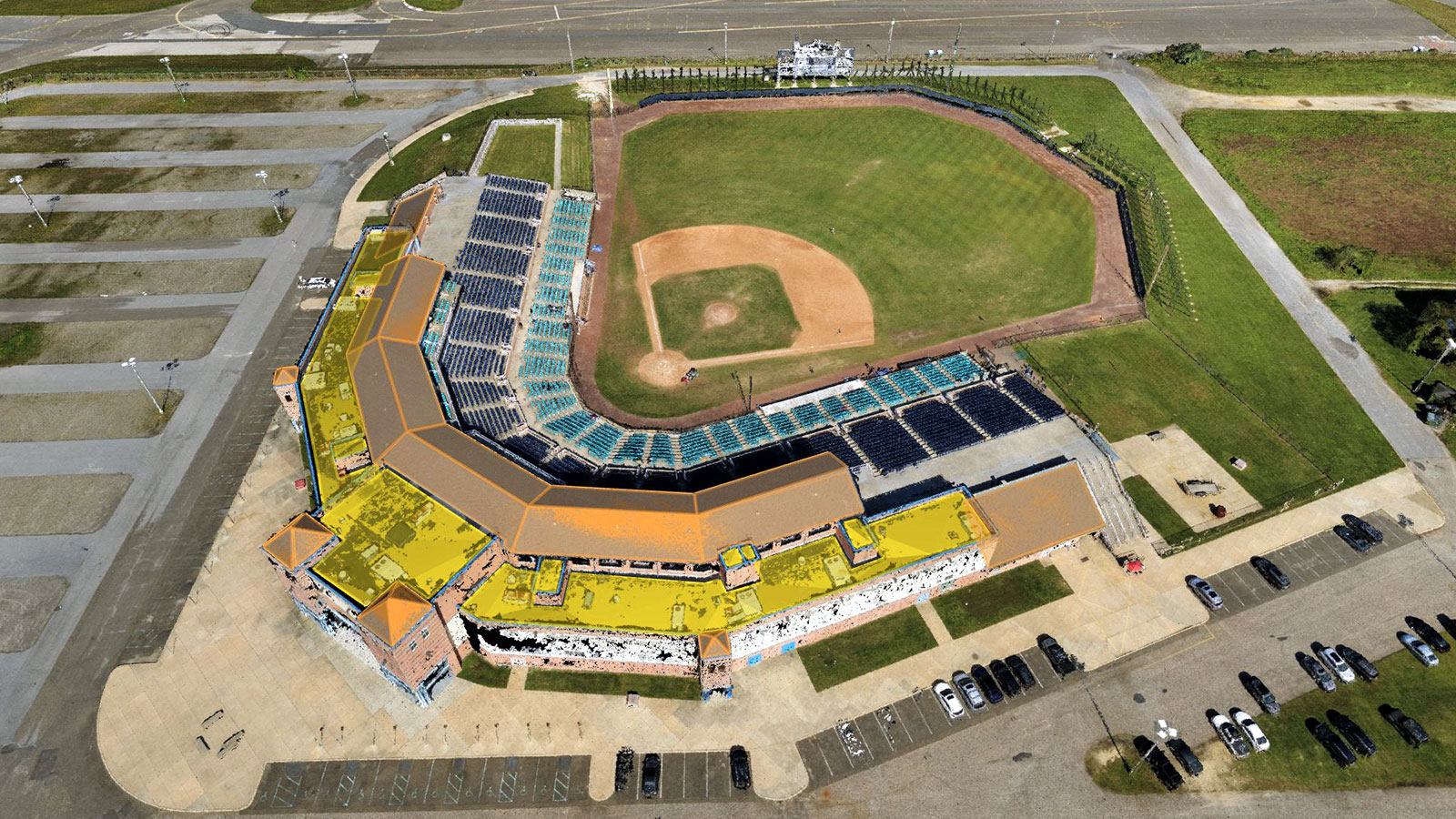
After data collection is completed for drone photogrammetry, the processing stage comes next. The pilot did not use GCPs for this project and uploaded the data directly from Pix4Dcapture to PIX4Dcloud. With over 2,300 images collected, processing on the cloud platform freed up local computer power whilst the outputs were generated. The orthomosaic, dense point cloud, and 3D mesh were very useful for starting the process of surveying the airfield including:
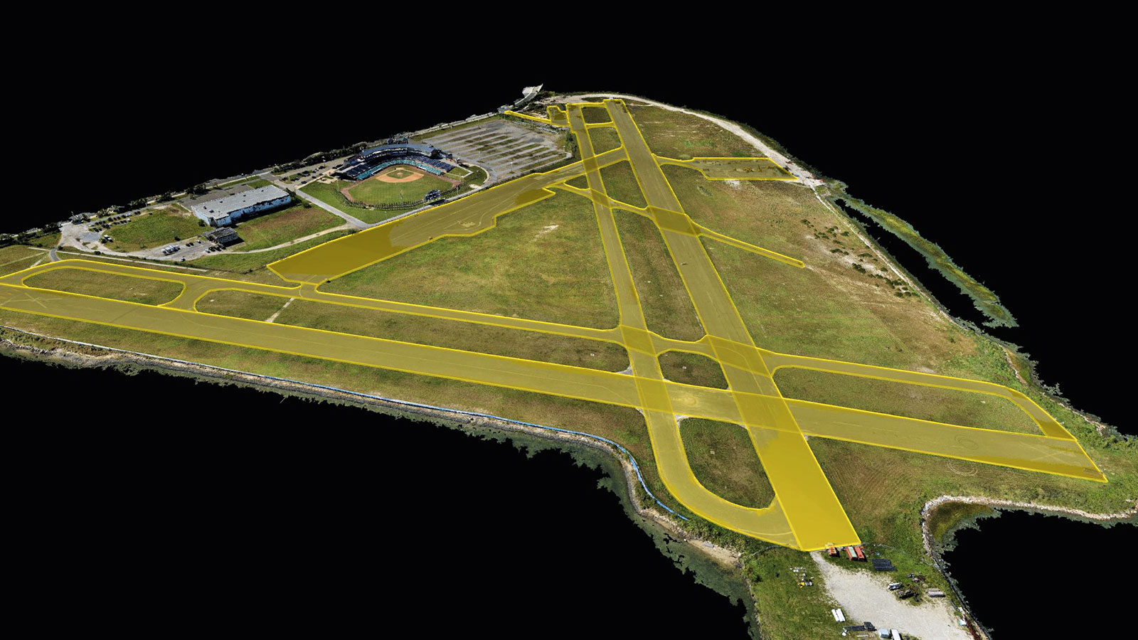
- Measuring the areas of runways, roads, paths, parking, grasslands, buildings, and fencing
- Monitor ongoing sewer line replacement and repair work
- Locate equipment, trailers, and refuse containers from events
- Locate boat ramps by the water
The value of vectorization
Vectorizing an area enables users to plan the lay of the land for future development and integration with CAD.
The project was seamlessly imported to PIX4Dsurvey, the software allowing users to vectorize point clouds with billions of points, capable of handling photogrammetry and LiDAR data in one same project. The software is an intersection of LiDAR and photogrammetry, taking advantage fo the capabilities of both.
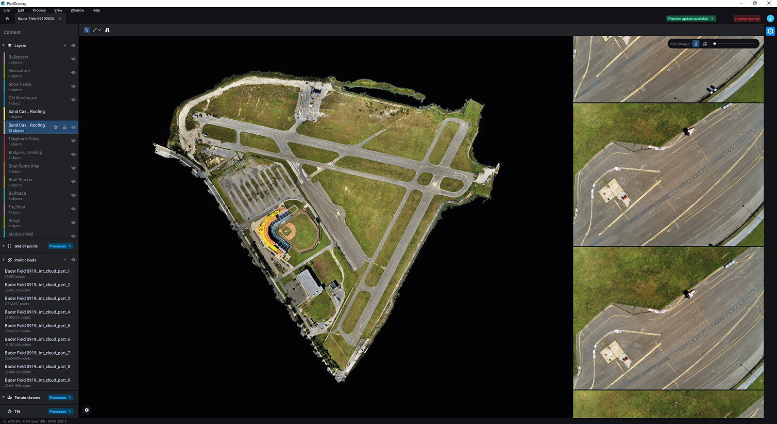
The 3D vectorization was available in less than two hours. This is better than a 2D alternative, as 2D analysis can falsely categorize areas with sloped gradients incorrectly. The Pix4Dsurvey data helps measure the area of sloped spaces, including the incline of the boat ramps. Photogrammetry surveying with PIX4Dsurvey also provides an elevation model of the area for assessing flood risks and planning flood mitigation. This is especially useful for planning large events being hosted on-site like concerts and festivals, where big structures may be left in place for weeks.
“A major advantage has been that this project was mostly completed using just one family of products: Pix4D for flight planning, processing, and vectorization.” Firefighter Jamieson Allen, Hazmat Coordinator
Similarly, vectorizing the sewer line shows the area above ground, the location of the spare line and helps track the project. Vectorization of roof areas of the different buildings can help with estimates for roof repairs and replacements. Similarly, vectorizing stockpiles of material gives information about the amount of dirt and debris. Another benefit of vectorizing the site is that the data gathered from vectorizing the roads and parking lots is very useful for estimating repaving needs and identifying flaws - especially with PIX4Dsurvey’s automatic road marking tool.
The value of Pix4D
The Atlantic City Office of Emergency Management managed to gather a significant quantity of data and turn it into actionable information that can be shared with a variety of stakeholders. Not only this, but even the team processing the data found they could easily work with any software.
“We found Pix4D to be very user-friendly software and although formal training was given to two members from the local community college, future training can be completed in-house.” - Firefighter Jamieson Allen
With Pix4Dcloud being fully automated as well, they were able to save time and energy during the processing stage. The outputs were used to plan and organize the Covid-19 testing site and Food Drive to be as efficient as possible. The Atlantic City authorities have already acted on the inspection of the roof of Fire Station 5 to carry out maintenance work. For the future, the Drone Program members believe that this data and project will have a huge effect on event planning and helping use Bader Field’s space more effectively.